Enter Excel Data Into Google Earth Pro (Desktop)
In the processing of large amounts of data, we often encounter a lot of excel data rows, such as building location data, bridge location, and tourism locations. of course, if you want to enter the data on the map, we do not want to enter it one by one. how do you enter these data into Google Earth quickly?
- Prepare your excel file and make sure there is a column that contains coordinate data in the decimal degrees format (Latitude and Longitude) then save your excel file in .csv (Comma Delimited) format.
- Open your Google Earth Pro (Desktop) application, then click the File menu -> Import... a data browsing window will appear. Change the file type in the file type column to the right of the file name, then select the excel file that you have prepared before.

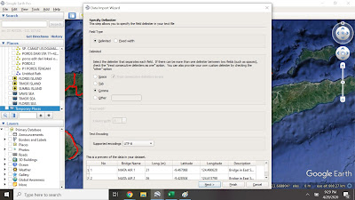
- Data Import Wizard window will appear. select Field Type (Delimited), Delimited select (Comma), Text Encoding (UTF-8), then click Next, then select Latitude and Longitude Field according to the columns in your excel file, click Next, the will display the data type that will be applied to our data. Click Finish.
A message will appear (Do you want to apply a style template to the features you are ingested? Click Yes. Style Template Options window will appear, select create new template and click Ok. Style Template Settings windows will appear, in this window we can choose the name of the column, choose the color per data, change the icon type and height of the icon from the ground. Then click Ok.Save your Google Earth File Templates (.kst) file. after that the kml file logo will appear with a type of .csv, click the checkbox to activate the layer. - Data Import Wizard window will appear. select Field Type (Delimited), Delimited select (Comma), Text Encoding (UTF-8), then click Next, then select Latitude and Longitude Field according to the columns in your excel file, click Next, the will display the data type that will be applied to our data. Click Finish.


Comments
Post a Comment